| Ocean: | Indian |
| Spreading center type: | Large-scale extinct MOR |
| Time of cessation: | Ca. 108 Ma, chron M7 (Robb et al., 2005), ca. 125 Ma, chron M3 (Gibbons et al., 2012), 126.7 Ma, chron M4 (Mihut and Muller, 1998) |
| Subsequent active spreading center: | Wharton Basin Ridge/SEIR(?) |
| Cessation style: | Gradual propagation of new axial segments, replacing older segments does not suggest an abrupt transition at the extinct spreading segments. |
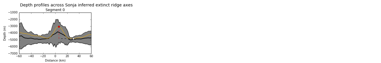
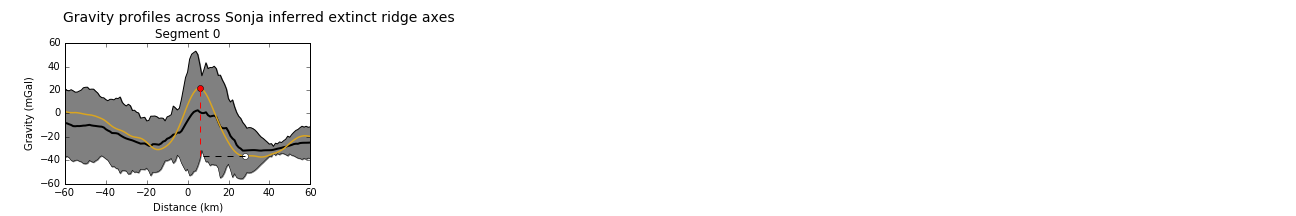
| Later deformation or volcanism: | It seems likely that later volcanism has modified the spreading center, forming elevated ridges after cessation. Reactivation of faults has also been suggested, as discussed below. |
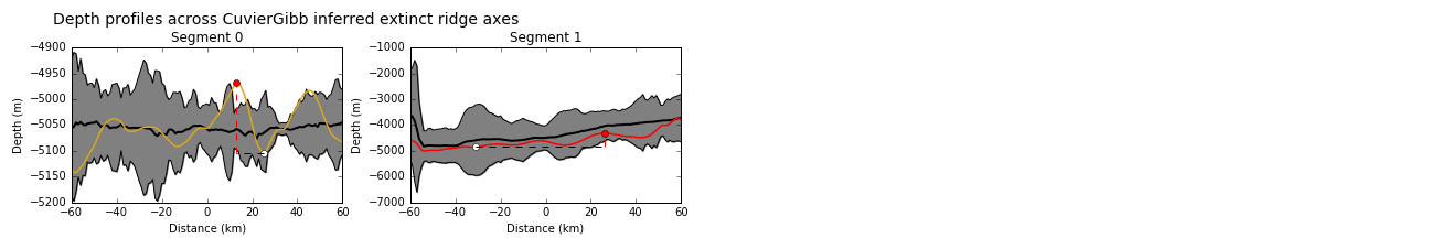
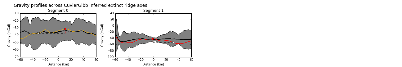
Similarly to the Perth Abyssal Plain (ID 2.7), there is some controversy regarding the location of former spreading axes offshore northern Western Australia due to irregular bathymetry and complex structures within the Cuvier and Gascoyne Abyssal Plains, west of the Exmouth Plateau. The oldest oceanic crust along this coastline is found within the Argo Abyssal Plain and is reported to date from the Late Jurassic (Falvey and Veevers, 1974). The sequence of magnetic anomalies associated with this spreading is one sided and there is no evidence of an extinct spreading center within the Argo Abyssal Plain.
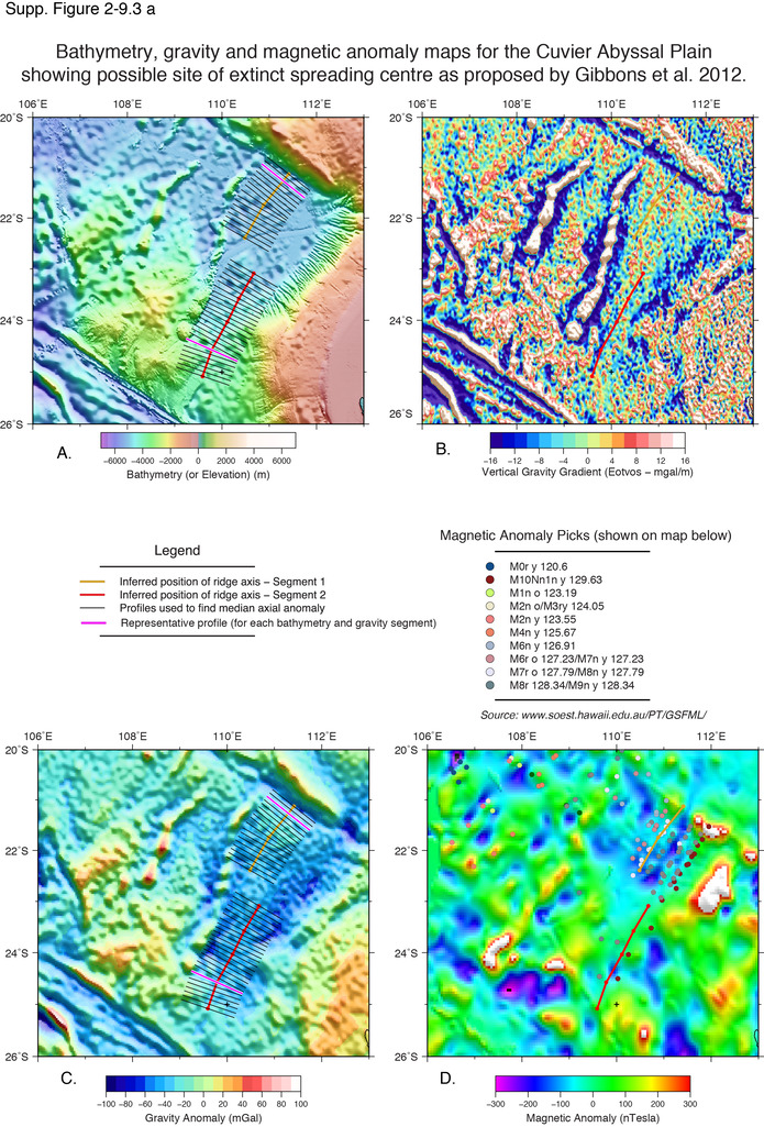
Magnetic anomalies have been identified within the Cuvier Abyssal Plain and the Gascoyne Abyssal Plains, yet there are several different interpretations of the sequence that these reflect (Larson et al., 1979; Fullerton et al., 1989; Mihut and Müller, 1998; Robb et al., 2005; Gibbons et al., 2012). The crust in this region was initially believed to have formed in the Early Cretaceous and Larson et al. (1979) proposed that magnetic anomalies M10 to M5 could be identified and that a significant ridge jump of around 220 km had likely occurred at ca. 118 Ma, resulting in an extinct ridge northeast of the Wallaby Plateau. A later work by Fullerton (1989) was largely consistent with Larson’s identifications, yet slightly improved constraints on proposed former spreading axis.
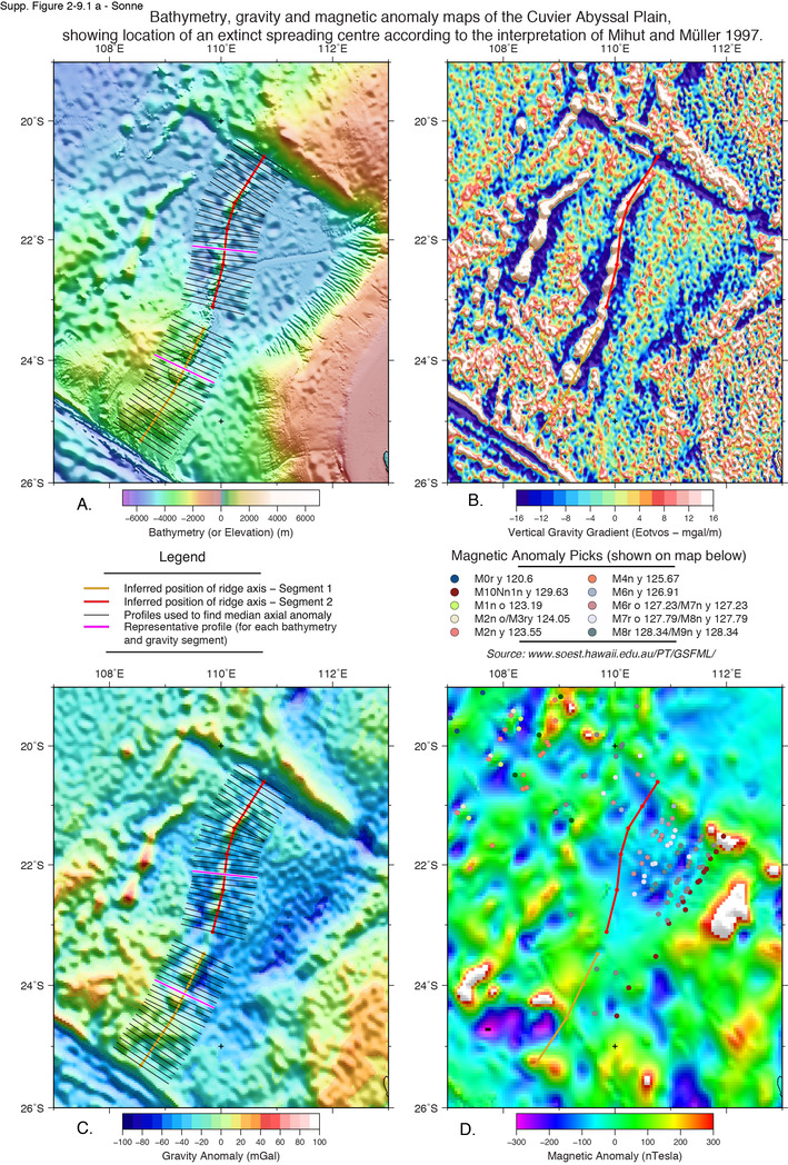
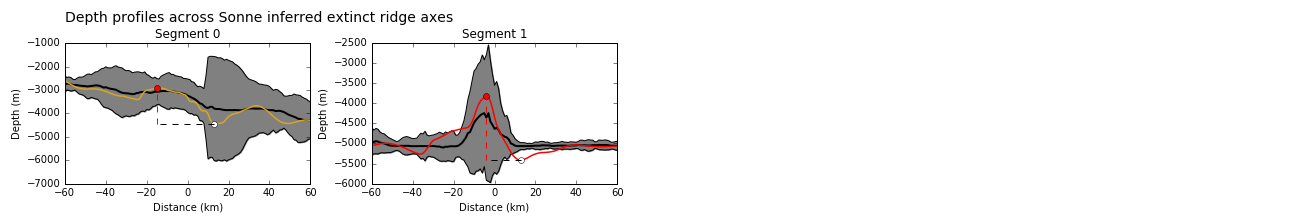
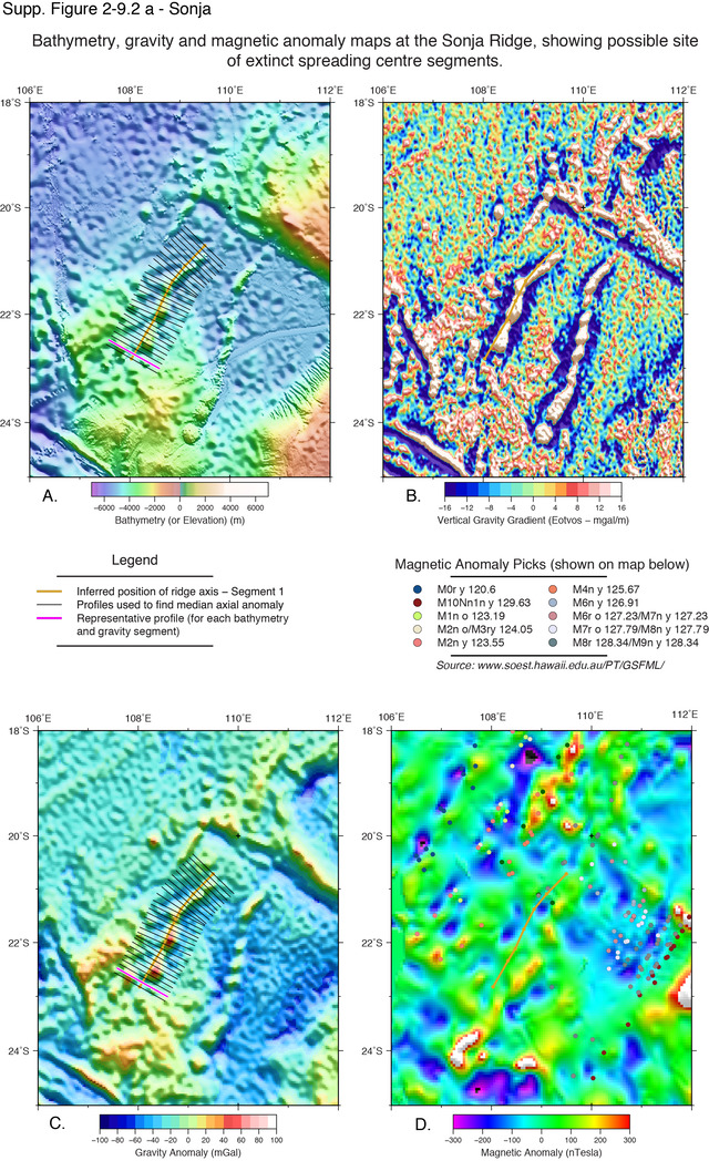
Mihut and Müller (1998) proposed that the Sonne Ridge may have been a former spreading axes and that the Sonja ridge represented a pseudofault formed by migration of the propagating spreading center. They reinterpreted magnetic anomalies and suggested that anomalies M12 and M11 could be identified within a region that was previously considered to be eastward of the continent-ocean boundary (Mihut and Müller, 1998). They propose that the Sonne Ridge extinct ridge axis formed through gradual propagation of the plate boundary, by a succession of small-scale reorganisations of transform faults and active/inactive spreading segments between M11 until M4 (Mihut and Müller, 1998). Mihut and Müller (1998) propose that the spreading centre then shifted to a location near the Wallaby Ridge, which became a second extinct spreading ridges. The unusual morphology of both the Sonne and Sonja ridges have been shown to be of volcanic origin and Mihut and Müller (1998) calculate the elastic thickness of the surrounding oceanic crust to estimate the timing of the volcanic emplacement. They argue that this must have occurred within 10 Myrs of the ridges extinction and migration.
An alternative interpretation was made by Robb et al. (2005), who proposed that the Sonja ridge was a further northward propagating spreading ridge, rather than a pseudfault, and that it had likely replaced the Sonne Ridge after M4, although they consider that it may have been active contemporaneously in the last stages of spreading on the Sonne Ridge. Robb et al. (2005) proposed this interpretation on the basis of a re-interpretation of the magnetic anomalies and review of the morphology of the two ridges, with the Sonja Ridge not characterized by a fault scarp. Given the possibility of later volcanic modification, this argument does not provide conclusive evidence of the genetic origin of the ridge.
Gibbons et al. (2012) later proposed that the Sonne Ridge had not been an axis of spreading and instead represented that it represents a pseudofault. They moved the position of the inferred extinct ridge on the Cuvier Abyssal Plain to the east of the Sonne ridge, suggesting that it was formed between M7 and M8, and that a second extinct spreading axis was present at the Sonja Ridge, as suggested by Robb et al. (2005).
Mihut and Müller (1998) suggest that plume-related volcanism may have uplifted the Wallaby and Zenith volcanic plateaus as the Australian plate moved eastward, relative to the Indian plate. They alternatively suggest that small-scale convection may have operated in the region but could have been disrupted by the motion of the Indian continental plate to a position adjacent the Gascoyne Plateau, which would have blocked continued flow and also resulted in ridge migration to the south (Mihut and Müller, 1998). There has been limited support for a hotspot influence in the migration, due to the broad distribution of volcanism throughout the area, which is similar to that described in the Wharton basin (Hébert et al., 1999), and therefore is unlike other hotspot related volcanism, such as linear hotspot tracks or large-igneous provinces.
We chose to assess the proposed extinct ridge locations of Gibbons et al. (2013), Robb et al. (2005) and Mihut and Müller (1998). None of these can be seen to show an ideal expression of an extinct spreading axis and it is very likely that the former spreading axis (or axes) was modified by later volcanism and/or deformation after extinction. It is likely that there may have been more than one active spreading center present on the Cuvier Abyssal Plain and that multiple ridge jumps may have taken place during separation of India from Australia.
Fullerton, L.G., Sager, W.W. and Handmuscher, D., 1989, Late Jurassic‐Early Cretaceous evolution of the eastern Indian Ocean adjacent to northwest Australia, Journal of Geophysical Research, v. 94, no. B3, p. 2937–2953.
Gibbons, A.D., Whittaker, J.M. and Müller, R.D., 2013, The breakup of East Gondwana: Assimilating constraints from Cretaceous ocean basins around India into a best-fit tectonic model, Journal of Geophysical Research: Solid Earth, v. 118, no. 3, p. 808–822.
Hébert,, H., Villemant, B., Deplus, C. and Diament, M., 1999, Contrasting geophysical and geochemical signatures of a volcano at the axis of the Wharton Fossil Ridge (N-E Indian Ocean), Geophysical Research Letters, v. 26, no. 8, p. 1053–1056.
Larson, R.L., Mutter, J.C., Diebold, J.B., Carpenter, G.B. and Symonds, P., 1979, Cuvier Basin: A product of ocean crust formation by Early Cretaceous rifting off western Australia, Earth and Planetary Science Letters, v. 45, p.105–114.
Mihut, D. and Müller, R.D., 1998. Volcanic margin formation and Mesozoic rift propagators in the Cuvier Abyssal Plain off Western Australia. Journal of Geophysical Research: Solid Earth, v. 103, no. B11, p. 27,135–27,149.
Rey, S.S., Planke, S., Symonds, P.A. and Faleide, J.I., 2008. Seismic volcanostratigraphy of the Gascoyne margin, Western Australia. Journal of Volcanology and Geothermal Research, v. 172, no. 1, p. 112-131.
Robb, M.S., Taylor, B. and Goodliffe, A.M., 2005. Re-examination of the magnetic lineations of the Gascoyne and Cuvier Abyssal Plains, off NW Australia, Geophysical Journal International, v. 163, no. 1, p. 42–55.