| Ocean: | Indian |
| Spreading center type: | Large-scale MOR |
| Time of cessation: | CTQZ |
| Subsequent active spreading center: | Wharton Basin Ridge/SEIR(?) |
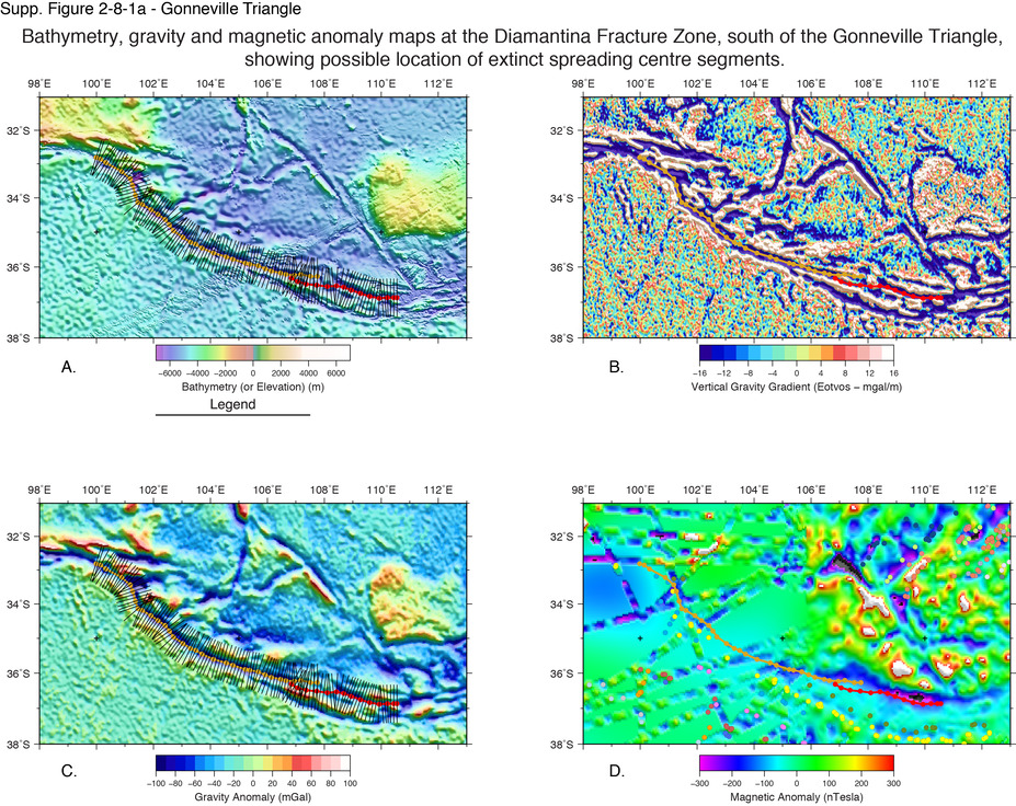
Whilst age determinations of the Perth Abyssal Plain (AP) extinct ridges have been controversial, the southern part of the basin, bordered by Broken Ridge, the Naturaliste Plateau, and the Diamantina fracture zone (FZ) is very poorly constrained. A French research cruise undertaken in 1994 collected seismic profiles across the region and inferred that the crust had been formed by Australian-Antarctic seafloor spreading between 120 and 90 Ma (Munschy, 1998). It was argued that an extinct spreading axis was represented by a shallow trough, approximately parallel to the Diamantina FZ and slightly to the north of the FZ. Samples dredged from a ridge that appears to be orthogonal to the inferred axis were found to be alkali basalts and peroditites, which presented evidence for a non-spreading-center origin (Chatin et al., 1998). Volcanic samples from this location were estimated to be 93 ± 4 Myr in age (formed during the Cretaceous Quiet Zone), which is consistent with the lack of magnetic anomalies within the basin and significantly post-dating the proposed age of the Kerguelen Plume (Munschy, 1998; Chatin et al., 1998).
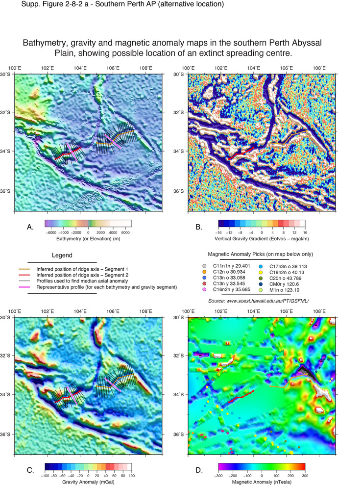
The depth of the basin is similar to that of the eastern Perth AP, suggesting a similar formation time, and is significantly deeper than the younger crust formed at the present-day SEIR, south of the Diamantina FZ. The oceanic crust is complicated by a forked trough, with one fork of this structure trending SE from the southern extent of the Dirk Hartog Ridge, and then from a three-way junction, one limb trends southwest to meet the Diamantina FZ at 102° E 35° S, and the other limb trends to the northeast and is truncated by the Naturaliste FZ at its most northerly point near 107° E 33° S.
Royer and Sandwell (1989) interpreted the crust to the north of the Diamantina FZ as conjugate to crust within the Labuan Basin, and proposed that the Australian-Antarctic plate boundary was preserved within the Diamantina zone, as illustrated in their Figure 10. However, there remains limited explanation of the complex structures within this basin and for this reason we have assessed the morphology and gravity signal of the trough that cross-cuts the basin in addition to Munschy’s proposed extinct spreading centre.
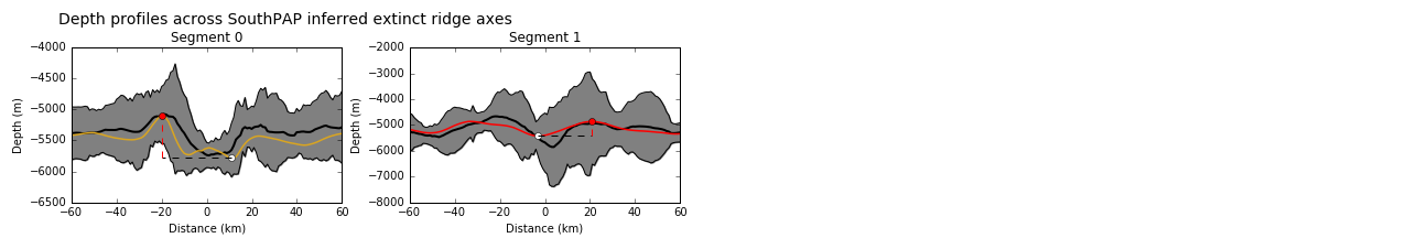
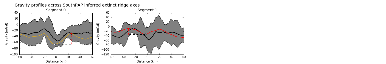
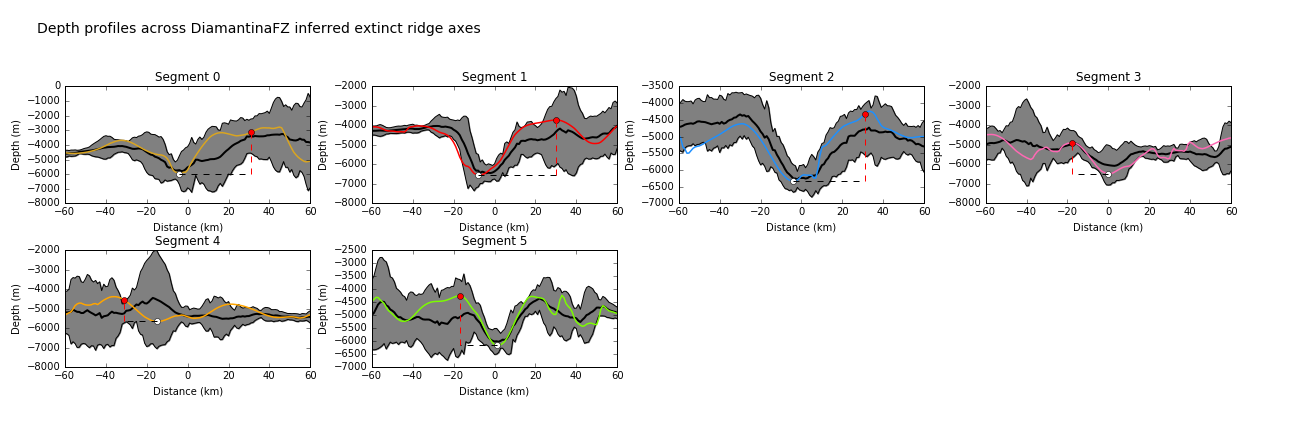
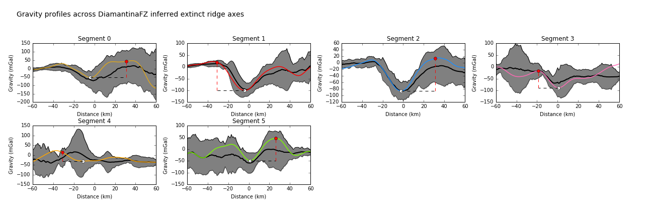
We consider the extinct ridge location proposed by Munschy (1998), adjacent to the Diamantina FZ, and also assess a northeast-southwest orientated linear feature in the Gonneville Triangle, as shown on maps below. The bathymetric relief and negative gravity anomalies at the inferred axial segments alongside the Diamantina fracture zone are mostly more than a standard deviation removed from the mean of the 'well-defined' extinct ridges for these parameters. They are within the range of the primary tier ridges, however profiles across the feature suggest that most of the segments are somewhat asymmetric and may be better interpreted as a fracture zone. The possible segments assessed within the Gonneville Triangle have bathymetric relief and peak-to-trough gravity signal that is within a standard deviation of the primary tier mean for these parameters. Profiles across the segments do not have a mrophology of an idealised extinct ridge signature, but Segment 0 bears some similarity to the signal observed at the Adare Trough extinct ridge (ID 3-01).
Chatin, F. et al., 1998, The Diamantina rift zone (eastern Indian Ocean): petrological and geochemical approach. Comptes Rendus de l’Académie des Sciences - Series IIA - Earth and Planetary Sciencemie des Sciences-Series IIA-Earth and Planetary Science, v. 326, no. 12, p. 839–845.
Munschy, M., 1998, The Diamantina Zone as the result of rifting between Australia and Antarctica: geophysical contraints, Comptes Rendus de l'Academie des Sciences Series IIA Earth and Planetary Science, v. 8, no. 327, p. 533-540.
Munschy, M., Dyment, J., Boulanger, M.O., Boulanger, D., Tissot, J.D., Schlich, R., Rotstein, Y. and Coffin, M.F., 1992, Breakup and sea floor spreading between the Kerguelen Plateau-Labuan Basin and Broken Ridge-Diamantina Zone, Proceedings of the Ocean Drilling Program, Scientific Results, 120, pp.931–944.
Royer, J. and Sandwell, D., 1989, Evolution of the Eastern Indian Ocean since the Late Cretaceous: Constraints from Geosat Altimetry, Journal of Geophysical Research, v. 94, no. B10, p. 13,755–13,782.