| Ocean: | Indian |
| Spreading center type: | Large-scale extinct MOR |
| Time of cessation: | Ca. 120 Ma, Chron M0 (Gibbons et al., 2012) or 124 Ma, M2 (Gaina et al., 2007) |
| Cessation style: | Argued to have been an abrupt cessation (Gaina et al., 2007) |
| Later deformation or volcanism: | This region has been affected by later volcanism related to activity of the Kerguelen Plume that has created volcanic edifices and thick volcaniclastic sequences within the Enderby Basin. |
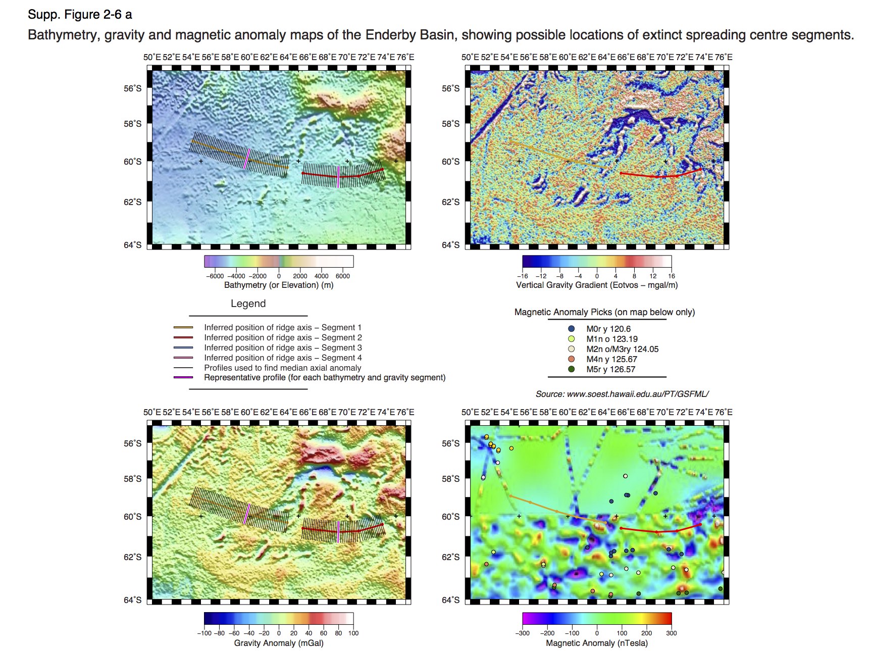
There is good consensus that an extinct spreading center must be situated within the Enderby Basin (Gaina et al., 2007; Gibbons et al., 2013; Nicolaysen et al., 2001; Bénard et al., 2010), in order for the Elan Bank continental fragment to have become isolated during breakup between Antarctica and India-Australia, yet it has been difficult to confirm the exact location of the center.
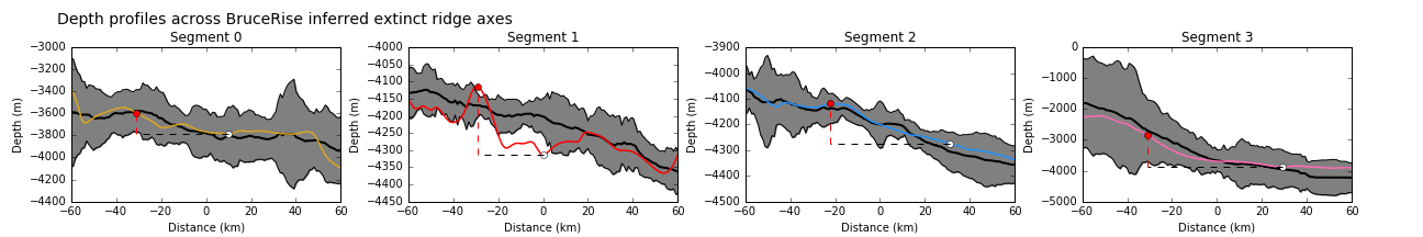
No fracture zone trends are identifiable within the basin and there are no linear gravity or bathymetric features that are indicative of a ridge structure. However, symmetric magnetic anomalies have been proposed within the basin (Gaina et al., 2007) and are reported to be of Mesozoic age (sequence M9 – M2), that are proposed to be symmetric about an extinct axis. Gibbons et al. (2012) later interpreted a sloghtly different extinct ridge location in the West Enderby Basin and proposed that spreading cessation along the entire Antarctic margin of the Enderby Basin was synchronous, rather than progressively developing from the east to the west as suggested by Gaina et al. (2007).
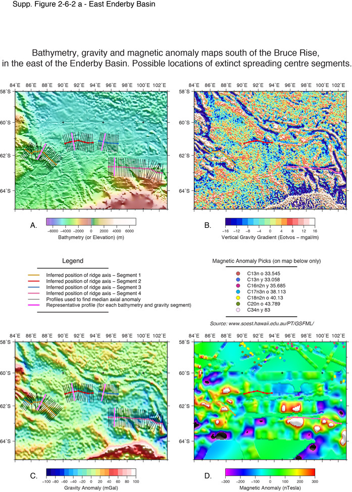
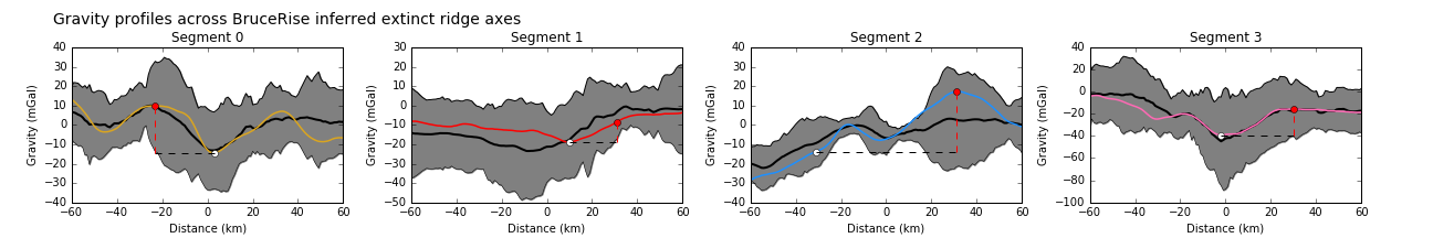
Gaina et al. (2007) propose that the Enderby Basin extinct axis is (uncharacteristically) represented by a gravity high. Gaina et al. (2007) explain this gravity signature as a result of a sudden cessation of spreading and a relatively rapid migration of the spreading center to the north of the Elan Bank. Gaina et al. (2007) also propose that a ridge extinction occurred in the east of the Enderby Basin, just south of the later formed Labuan Basin, at ca. M4, slightly earlier than the extinction event in the central Enderby Basin that is proposed to have occurred between M2 and M0. Possible locations of these eastern segments are shown on maps of the south Bruce Rise, shown below.
Gaina et al. (2007) suggest that the Kerguelen Plume was likely to have been positioned at 35 S at 118 Ma and that this would have been within sufficient distance of the Enderby Basin spreading center to have caused a northward migration of the active spreading center. Gaina et al. (2007) observed a metamorphic core complex in the Enderby Basin, that they believe was possibly caused by a locally, anomalously hot mantle, leading to a weakened lower crust. However, Gaina et al. (2007), stated that the influence of the Kerguelen plume on break-up would have been secondary to rifting due to active subduction at the northern margin of the Meso-Tethys. Bénard et al. (2010), on the basis of extended continental crust within the Elan Bank, and South and Central Kerguelen Plateaus, support the identification of an extinct ridge in the Enderby Basin, as proposed by Gaina et al. (2007).
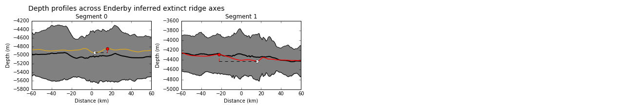
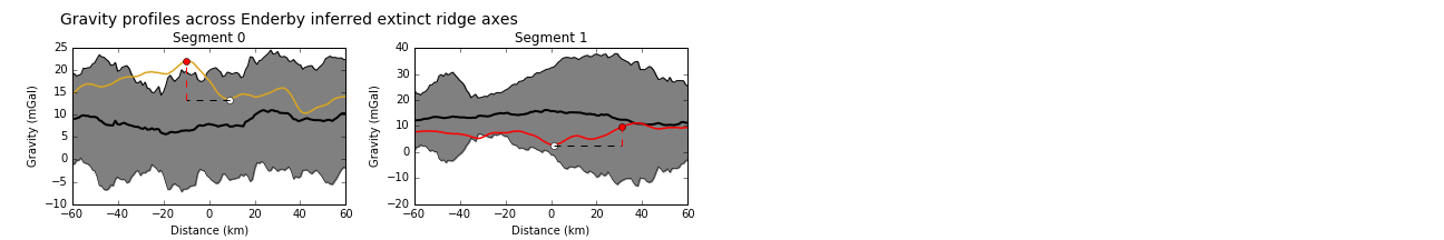
We have had limited success in isolating the location of the extinct spreading center axis within the Enderby Basin. Whilst the morphology of the Enderby Basin is rough and inhomogenous, there were no features that could be readily identified as either axial valleys or ridges. As a result, our placement of segments was tentative and uncertain and primarily informed by identified magnetic anomalies within the basin. Therefore, there is a considerable amount of variation in bathymetric relief and gravity signal around our inferred placements. The segments we considered in the east of the basin, south of the Bruce Rise were less clear in expression and do not strongly suggest that we have located the extinct spreading axis within this region.
Bénard, F., Callot, J.-P., Vially, R., Schmitz, J., Roest, W., Patriat, M., Loubrieu, B. and the ExtraPlac Team, 2010. The Kerguelen plateua: records from a long-living/composite microcontinent, Marine and Petroleum Geology, v. 27, p. 633-649.
Gaina, C., Müller, R. D., Brown, B. and Ishihara, T., 2003, Microcontinent formation around Australia, Geological Society of Australia Special Publication, v. 22, pp.399–410.
Gaina, C., Müller, R. D., Brown, B. Ishihara, T. and Ivanov, S., 2007, Breakup and early seafloor spreading between India and Antarctica. Geophysical Journal International, v. 170, no. 1, p. 151–169.
Gibbons, A. D., Whittaker, J. M. and Müller, R. D., 2013, The breakup of East Gondwana: assimiliating constraints from Cretaceous ocean basins around India into a best-fit tectonic model, Journal of Geophysical Research, v. 118, p. 808-822.
Nicolaysen et al., 2001, Provenance of Proterozoic garnet-biotite gneiss recovered from Elan Bank, Kerguelen Plateau, southern Indian Ocean, Geology, v. 29, no. 3, p. 235-238.