| Ocean: | Indian |
| Spreading center type: | Inconclusive evidence that the features reviewed represent an extinct spreading center. It is possible that they are fracture zones or pseudofaults developed during ridge reorganizations. |
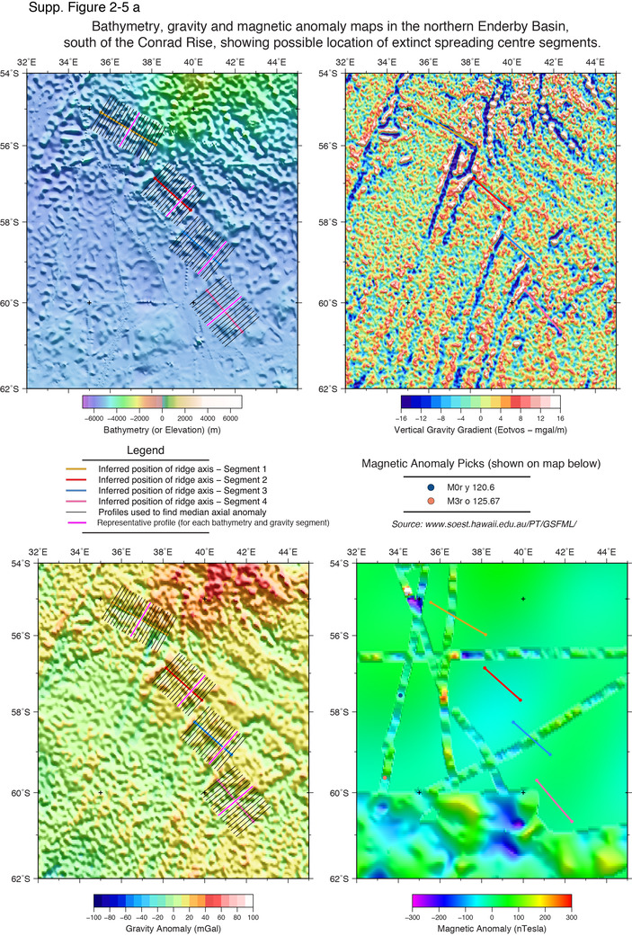
Several studies have proposed that there was an additional spreading center situated in the northern Enderby Basin (additonal to the reported extinct ridge in the Enderby Basin [ID: 2-06]), on the basis of complex tectonic fabrics and interpretation of magnetic anomalies (Nogi et al., 2004; Desa et al., 2006). Although data is sparse in this region, Nogi et al. (1996) used a three-component magnetometer to measure the vector geomagnetic field, and argue that this method provides an indication of the strike of magnetic lineations within the region. Nogi et al. (1996) observed discontinuities in the magnetic lineations, that suggest a change in spreading direction during the opening of the basin. They interpret a change in trend of magnetic anomalies from a NW-SE orientation up to a latitude of around 65° N, close to the Antarctic margin, and to the east of the Gunnerus Ridge, to a NE-SW orientation in the north, which entails a change in orientation of ca. 120 degrees (Nogi et al., 1996).
Curvature of fracture zones at 42° E and 60° S is evident in updated gravity maps (Sandwell et al., 2014) and this is supports a change in spreading direction to the north of the Gunnerus Ridge. Nogi et al. (2004), reviewed the northerly region and on the basis of fracture zone orientation and their interpretation of the magnetic anomalies in the region, propose that there may be several extinct spreading center segments between the Gunnerus Ridge and Antarctica. They place the inferred axis just south of the fracture zone curvature at 60° S and a second possible extinct ridge segment is suggested in a more northerly position near 55° S, at longitude 33° E.
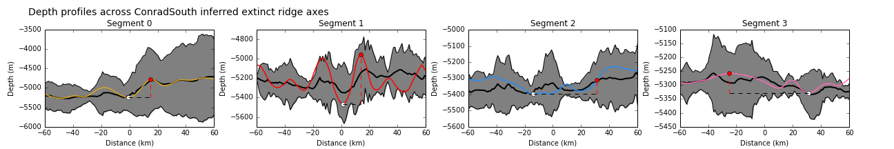
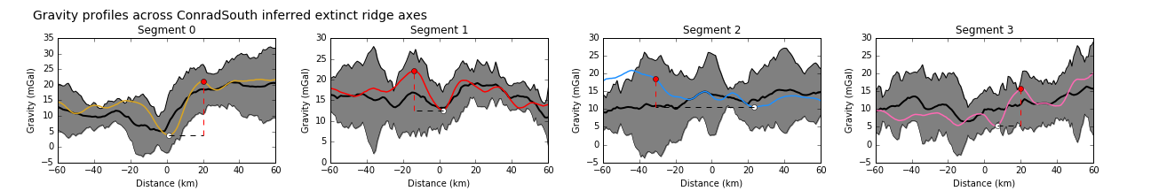
This study considered that the most likely location for an extinct spreading center within the northern Enderby Basin is to the north of 60° S, where several NW-SE oriented, short-linear negative gravity anomalies are observed to extend over a distance of ca. 600 km. These segments were digitized and profiles across the inferred axes give some idea of the bathymetric relief across these features, which varies from 50 to 500 m, and has a subdued negative free-air gravity anomaly of 4-12 mGals in peak-to-trough magnitude. The form of these anomalies is unlike the characteristic signal seen at well-defined spreading centers. Although the linear features suggest a discontinuity in spreading fabric, there is insufficient evidence to conclude that this feature represents a preserved extinct spreading center.
Desa M., Ramana, M.V. and Ramprasad, T., 2006, Seafloor spreading magnetic anomalies south off Sri Lanka, Marine Geology, v. 229, no. 3-4, p. 227–240.
Nogi, Y. et al., 1996, Magnetic anomaly lineations and fracture zones deduced from vector magnetic anomalies in the West Enderby Basin, Geological Society, London, Special Publications, v. 108, no. 1, p. 265–273.
Nogi et al., 2004, An Interpretation of the Seafloor Spreading History of the West Enderby Basin between Initial Breakup of Gondwana and Anomaly C34, Marine Geophysical Researches, v. 25, no. 3-4, p. 221–231.
Sandwell, D., Müller, R. D., Smith, W. H. F., Garcia, E. S., Francis, R., 2014, New global marine gravity model from CryoSat-2 and Jason-1 reveals buried tectonic structure, Science, v. 346, no. 6205, p. 65-67.