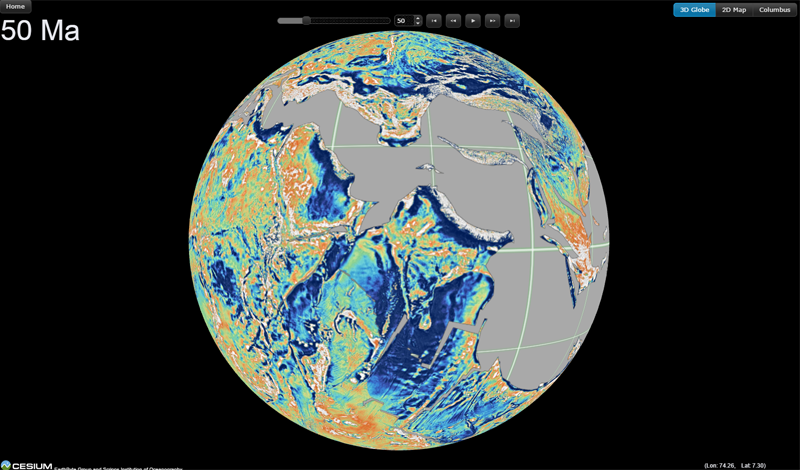
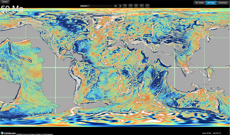
Gravity and magnetic maps are a fundamental tool for mapping the tectonic fabric of the ocean floor,
allowing us to reconstruct many millions of years of Earth's plate tectonic evolution. We use the plate tectonic reconstruction software
GPlates, combined with reconstruction models developed by members of the Earthbyte group,
to reconstruct geophysical images and explore the spatio-temporal relationships between present-day seafloor morphology and plate tectonic processes.
This tutorial
contains detailed information about how to reconstruct rasters with GPlates.
press the button below to explore the reconstruction within your web browser using an interactive 3D visualisation
Sandwell et al.(2014).
Gravity Anomalies Reconstruction
References
- Seton, M., Müller, R.D., Zahirovic, S., Gaina, C., Torsvik, T.H., Shephard, G., Talsma, A., Gurnis, M., Turner, M., Maus, S., Chandler, M.(2012),
Global continental and ocean basin reconstructions since 200 Ma.
Earth-Science Reviews, Volume 113, Issues 3-4, July 2012, Pages 212-270, ISSN 0012-8252, doi:10.1016/j.earscirev.2012.03.002
- Zahirovic, S., Seton, M. and Müller R. D. 2014.
The Cretaceous and Cenozoic tectonic evolution of Southeast Asia. Solid Earth, 5, 227-273. doi:10.5194/se-5-227-2014.
- Whittaker J.M., Williams S.E., Müller R.D., 2013.
Revised tectonic evolution of the Eastern Indian Ocean,
Geochem. Geophy. Geosyst., doi:10.1002/ggge.20120
- Gibbons, A.D., Whittaker, J.M., Müller R.D., 2013.
The breakup of East Gondwana: assimilating constraints from Cretaceous ocean basins around India into a best-fit tectonic model,
Journal of Geophysical Research, 118, 808-822, doi:10.1002/jgrb.50079
- Shephard, G.E., Müller R.D., and Seton, M., 2013.
The tectonic evolution of the Arctic since Pangea breakup: Integrating constraints from surface geology and geophysics with mantle structure.
Earth-Science Reviews, Volume 124 p.148-183. doi:10.1016/j.earscirev.2013.05.012
-
Cannon, J., Lau, E., and Müller, R. D., 2014.
Plate tectonic raster reconstruction in GPlates, Solid Earth, 5, 741-755, doi:10.5194/se-5-741-2014.
-
Williams, S., Müller, R.D., Landgrebe, T. C.W., Whittaker, J.M., 2012,
An open-source software environment for visualizing and refining plate tectonic reconstructions using high resolution geological and geophysical data sets.
GSA Today, 22, no. 4/5, doi: 10.1130/GSATG139A.1.
-
Heine, C., Zoethout, J., and Müller, R. D. 2013.
Kinematics of the South Atlantic rift, Solid Earth, 4, 215-253, 2013, doi: 10.5194/se-4-215-2013.