| Ocean: | Marginal basin |
| Spreading center type: | Large-scale extinct MOR |
| Time of cessation: | Ca. 129 Ma, before chron M9r (Kovacs et al., 2002) |
| Subsequent active spreading center: | Antarctic-South American spreading system |
The early development of the Weddell Sea remains poorly understood, due to limited data coverage and enigmatic structures within the Antarctic margin. A ‘Tectonic Map of Antarctica’ produced by Grikurov and Leychenkov (2012) for the Commission for the Geological Map of the World (CGMW), shows the earliest phase of oceanic spreading north of Coats Land with anomalies M19 – M11 along a 300-400 km stretch of the margin to the east of the Explora Wedge. Pressumed oceanic crust in the far west of the Weddell Sea to the south of 63° S and west of 48° W is not given an interpreted age due to limited data (Grikurov and Leychenkov, 2012). Magnetic anomalies M4 and M0 are identified to the north along 1000 km of the margin, before the “herring bone” tectonic fabric of the Weddell Sea in encountered (Grikurov and Leychenkov, 2012). The latter region has been mapped and identified as the anomaly sequence C34 to C5 (Livermore and Woollett 1993). Relatively limited Cretaceous Quiet Zone-formed crust is evident within the western Weddell Sea, compared with that seen in the South Atlantic and Indian Oceans, suggesting either long-lived ultra-slow spreading rates or a hiatus of spreading in this region. It is within the oceanic crust formed prior to C34 that a possible extinct spreading centre may be located.
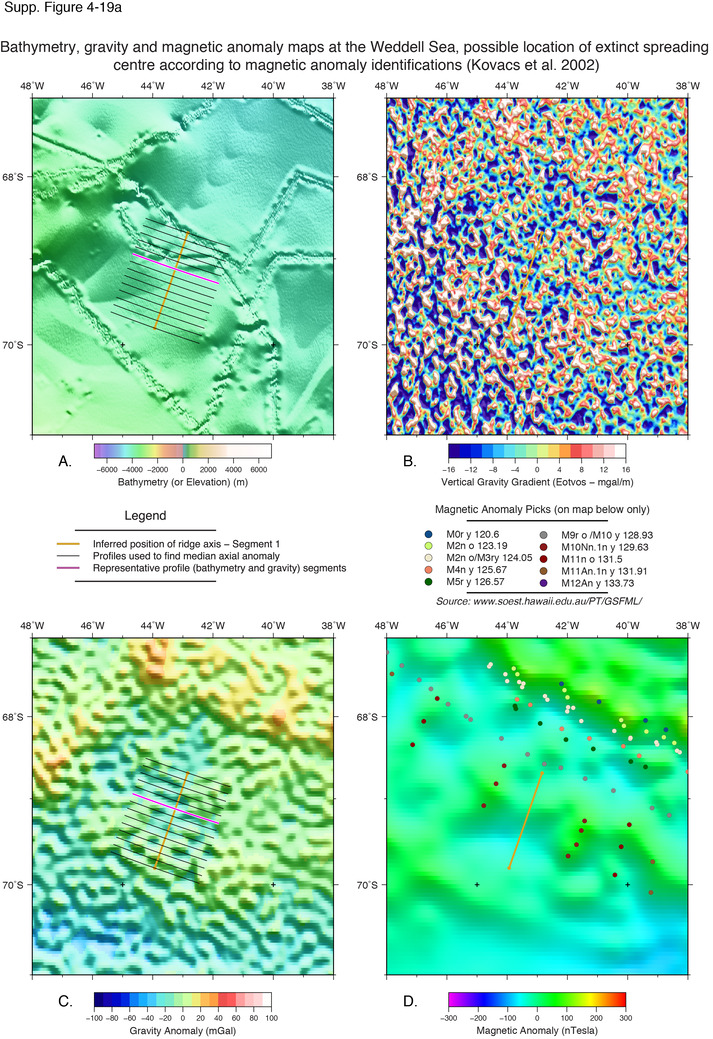
Livermore and Woolett (1993) suggested that anomaly sequence M4-M12 could be identified to the south of the herring bone pattern, with predicted spreading-rates of 15 mm/yr and a spreading direction consistent with later anomalies. Their interpretation suggested that conjugate crust formed in the northern Weddell Sea that has since been consumed at subduction zones on the southern margin of the eastern Antarctic Peninsula (Livermore and Woolett, 1993). An alternative interpretation was proposed by Kovacs et al. (2002), who suggest that east-west oriented spreading took place during the Late Cretaceous and terminated shortly before M9 with a relatively short, North-South oriented extinct ridge proposed at around 43° W. This model requires extension and relative motion between East and West Antarctica from 137 Ma until ca. 129 Ma (Kovacs et al., 2002). The magnetic anomaly map produced by Golynsky et al. (2002) supports a sequence of N-S oriented spreading anomalies between 65° S and 70° S in the western Weddell Sea.
The interpretation of König and Jokat (2006), suggests a 20 Myr episode of rifting between East and West Antarctica from 167 Ma to ca. 150 Ma but suggests that all seafloor spreading was oriented in an approximately north-south direction, with anomalies M17 to M0 identified north of the Filchner Ice Shelf (see their Figure 7). Brewer et al. (1996) provide geochronology data for several magmatic bodies in Dronning Maud Land, Coats Land and the Dufex Intrusion (182 ± 2.4 Ma), on the South Atlantic margin of Antarctica between 45 W and 45 E, suggesting that there was widespread mid-Jurassic volcanism in the region at the time of failure of the Weddell Sea rift.
Curtis and Storey (1996) discount early Weddell Sea oceanic spreading and instead argue that rotation of the Ellesworth-Whitmore Mountains block (EWM) away from the Falkland blocks and subsequent crustal extension accounts for the current configuration of continental blocks in the region. Curtis and Storey (1996) suggested that the EWM block was situated outboard of the Falklands, west of the South African margin and that the block was subsequently translated further to the south west, which formed the dextral transpressive deformation observed within the block. This motion could also be explained if there was an active subduction zone in the Western Weddell Sea as suggested by Grunow (1993). This could have led to convergence of the block to the west, where it later became docked, however the placement of the proposed SZ is controversial. Grunow (1993) suggests that a back-arc basin formed in the Weddell Sea due to a long-lived subduction zone on the western side of the Antarctic Peninsula. Grunow (1993) proposed that although the basin was probably formed in the lower to middle Jurassic, a proportion of the crust formed there may have been consumed at a subduction zone at the southern end of the peninsula at ca. 130 Ma (Grunow, 1993).
The various interpretations of this complex region have their own implications for the timing and mechanisms of cessation within the possible Weddell Sea extinct ridge. It appears likely that the dramatic shift in orientation of the spreading center suggested by Kovacs et al (2002) reflected a large-scale change in the regional plate motions.
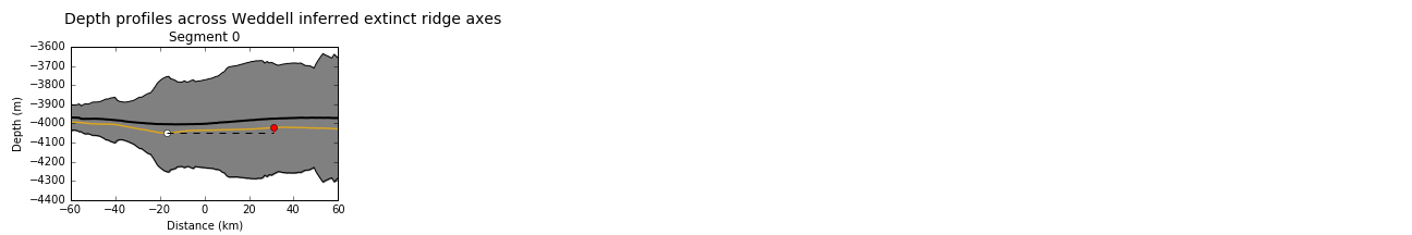
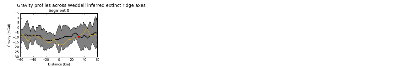
An east-west oriented short-lived spreading system has been predicted from magnetic anomaly maps by Kovacs et al. (2002). No bathymetric feature can be identified within the region of the possible extinct spreading center. However, a relatively subdued gravity low of around 10 mGals in evident, with half-width of ca. 20 km that is similar to other well-defined extinct spreading centers. The reduced magnitude of the gravity low is likely related to the older age of this possible spreading center, that is proposed to have formed over 129 Ma.
Brewer, T. S., Rex, D., Guise, P. G., and Hawkesworth, C. J., 1996, Geochronology of Mesozoic tholeiitic magmatism in Antarctica: implications for the development of the failed Weddell Sea rift system. Geological Society, London, Special Publications, v. 108, no. 1, p. 45–61.
Curtis, M.L. and Storey, B.C., 1996, A review of geological constraints on the pre-break-up position of the Ellsworth Mountains within Gondwana: implications for Weddell Sea evolution, Geological Society, London, Special Publications, v. 108, no. 1, p. 11–30.
Grikurov, G. E. and Leychenkov, G. 2012, Tectonic map of Antarctica, Scale 1: 10 000 000, First edition, Commision for the Geological Map of the World.
Golynsky, A. V., Morris, P., Kovacs, L. C. and Ferris, J. K., 2002, A new magnetic map of the Weddell Sea and the Antarctic Peninsula, Tectonophysics, v. 347, p. 3–11.
Grunow, A. M., 1993, New paleomagnetic data from the Antarctic Peninsula and their tectonic implications, Journal of Geophysical Research, v. 98, no. B8, p. 13815.
König, M. and Jokat, W., 2006, The Mesozoic breakup of the Weddell Sea, Journal of Geophysical Research, v. 111, no. B12102, doi: 10.1029/2005JB004035.
Kovacs, L.C., Morris, P., Brozena, J. and Tikku, A., 2002, Seafloor spreading in the Weddell Sea from magnetic and gravity data, Tectonophysics, v. 347, p. 43–64.
Livermore, R. and Woollett, R., 1993, Seafloor spreading in the Weddell Sea and southwest Atlantic since the Late Cretaceous, Earth and Planetary Science Letters, v. 117, p. 475–495.