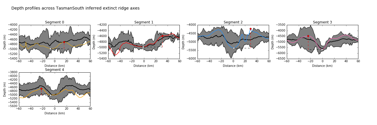
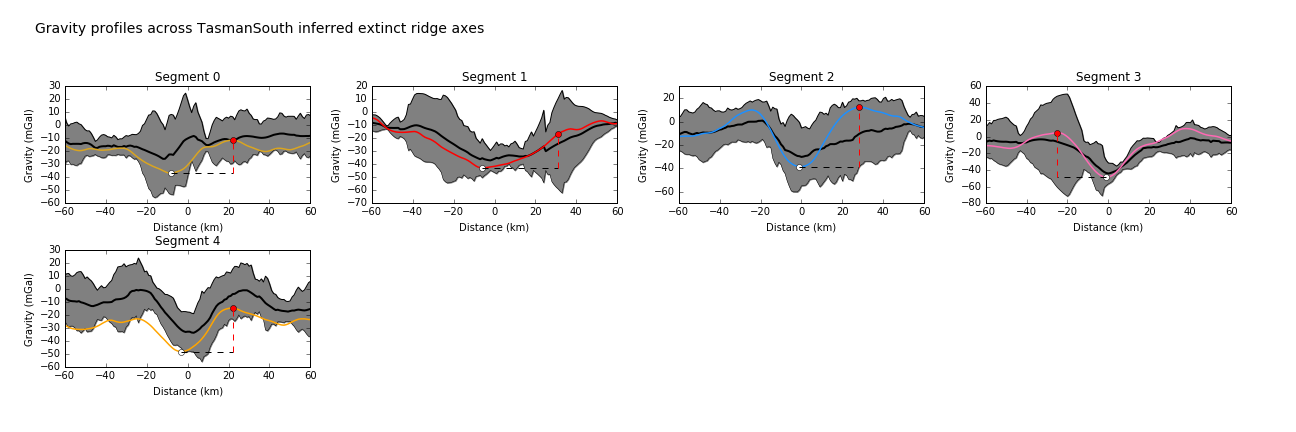
| Ocean: | Marginal basin, Southwest Pacific |
| Spreading center type: | Large-scale extinct MOR |
| Time of cessation: | Ca. 52 Ma, chron C24n (Gaina et al., 1998) |
| Cessation style: | Minor decrease in half-spreading rate from 20 to 16 mm/yr and change in spreading direction prior to extinction (Gaina et al., 1988). |
| Later deformation or volcanism: | None evident |
The Tasman Sea formed during separation of Eastern Australia from the Lord Howe Rise continental ribbon (now a largely submerged plateau) during the Late Cretaceous and early Paleogene (85 to 52 Ma) (Gaina et al., 1998). van der Linden (1969) inferred the presence of an extinct ridge between Australia and the Lord Howe Rise that formed after the Paleozoic on the basis of age estimations of the Lord Howe Rise crust and geosynclinal theory, but mistakenly he proposed that the Dampier Ridge was likely to have been the extinct axis of this spreading system. The accurate location of the extinct spreading center in the Tasman Sea was later described by Hayes and Ringis (1973) and an updated interpretation of the southern magnetic anomalies was presented by Weissel and Watts (1977), with both studies proposing that spreading ceased at ca. 60 Ma. The age of the oldest formed crust in the basin has been contentious and more recent studies have proposed a later time of cessation, after more detailed studies of the spreading axis (Gaina et al., 1998). It is possible that a regional ridge-reorganization may have occurred prior to opening of the Tasman Sea, with several authors arguing that the Middleton and Lord Howe Basins shortly preceded formation of the Tasman Sea and that a westward ridge jump had occurred, shifting active spreading to the west of the Lord Howe Rise, possibly at ca. 75 Ma (Weissel and Hayes, 1977).
Gaina et al. (1998) presented a more complex model for the opening of the Tasman Sea, in which they propose that several episodes of rotation of bounding continental blocks occurred during the basin opening and that the conjugate boundaries of the ocean basin were formed of a number of discrete continental blocks, rather than as a two plate system. Gaina et al. (1998) also suggested that there was some asymmetry at the spreading center between chrons 33y and 27o, with greater rates of crustal accretion on the eastern flank. It is proposed that spreading first developed in the south due to the motion of the Challenger Plateau, relative to the Lord Howe Rise, with an earlier formed failed rift proposed at the Bellona Trough (Gaina et al. 1998). Lanyon et al. (1993) proposed that the Balleny plume may have been an important influence on the development of the southern Tasman Sea and Weaver et al. (1994) also suggest an earlier influence of a plume with rifting of New Zealand from Marie Byrd Land, in the east of the Tasman Sea.
There is some question as to whether the spreading center was a mid-ocean ridge spreading center (Weissel and Hayes, 1977) or whether it was as a backarc basin (Schellart et al., 2006), given that westward dipping subduction to the east of the Lord Howe Rise is suggested by a number of models (for example, Bache et al., 2014). Weissel and Hayes (1977) suggested that a subduction zone was not present within this region during formation of the basin. The width of the Lord Howe Rise continental ribbon is greater than the width of many global backarc basins, which suggests that the distance from trench to spreading center is too great for a backarc basin origin.
There has been surprisingly little discussion of the reasons for spreading cessation within the Tasman Sea, although Gaina et al. (1998) suggested that it may have reflected a major change in regional plate motion and preceded the India-Eurasian collisional event (Chron 24).
Bache, 2014, Seismic stratigraphic record of transition from Mesozoic subduction to continental breakup in the Zealandia sector of eastern Gondwana. Gondwana Research, v. 26, p. 1060-1078.
Gaina, C., Müller, D.R., Royer, J.-Y., Stock, J., Hardebeck, J. and Symonds, P., 1998, The tectonic history of the Tasman Sea: A puzzle with 13 pieces, Journal of Geophysical Research, v. 103, no. B6, p. 12,413–12,433.
Hayes, D. E. and Ringis, J., 1973, Seafloor spreading in the Tasman Sea, Nature, v. 243, p. 454-458.
Lanyon, R., Varne, R. and Crawford, A., 1993. Tasmanian Tertiary basalts, the Balleny plume, and opening of the Tasman Sea (southwest Pacific Ocean). Geology, v. 21, no. 6, p. 555-558.
Schellart, W. P., Lister, G. and Toy, V. G., 2006, A Late Cretaceous and Cenozoic reconstruction of the Southwest Pacific region: Tectonics controlled by subduction and slab rollback processes, Earth-Science Reviews, v. 76, p. 191-233.
van der Linden, W. J. M., 1969, Extinct mid-ocean ridges in the Tasman Sea and the western Pacific. Earth and Planetary Science Letters, v. 6, p. 483-490.
Weaver, S., Storey, B.C. and Pankhurst, R., 1994, Antarctica-New Zealand rifting and Marie Byrd Land lithospheric magmatism linked to ridge subduction and mantle plume activity, Geology, v. 22, p. 811–814.
Weissel, J.K. and Hayes, D.E., 1977, Evolution of the Tasman Sea reappraised, Earth and Planetary Science Letters, v. 36, p. 77–84.