| Ocean: | Pacific |
| Spreading center type: | Microplate spreading ridge |
| Time of cessation: | Ca. 6 Ma, C4n1(y) (Eakins and Lonsdale, 2003) |
| Later deformation or volcanism: | There are several troughs and scarps with limited sedimentation relative to other features that are suggestive of later deformation (Anderson et al., 1978). |
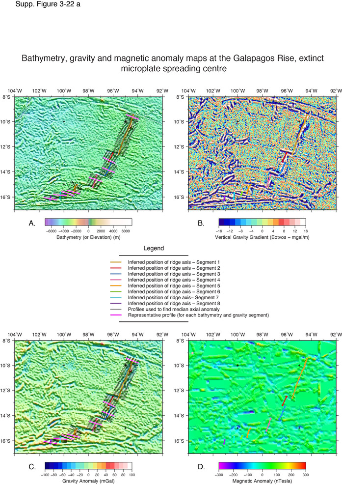
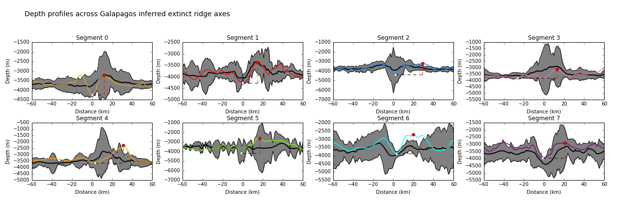
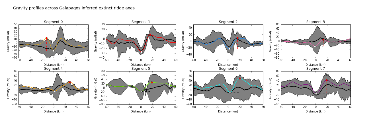
The Galapagos Rise should not to be confused with the active Galapagos Spreading Centre (shown in Sclater and Klitgord, 1973, Figure 1 inset), that is situated in proximity to the Galapagos Islands and is part of the Cocos-Nazca spreading ridge. The Galapagos Rise is instead an arcuate feature around 1000 km SSW of the islands that was responsible for the formation of a semi-circular region of oceanic crust between 6 and 10 Ma, that has was captured onto the Nazca plate after ridge extinction. The Galapagos Rise-formed crust is unfortunately largely devoid of magnetic isochron anomaly identifications, yet the axial segments have characteristic spreading centre morphology and well-defined fracture zones record the motion of crust away from the inferred spreading boundary. The ridge axis is segmented and can be subdivided into between 3 and 8 axial segments that vary in length, becoming much shorter in the south, where the crust pinches out suggesting that spreading rates were significantly higher in the north.
The Galapagos Rise was first identified by Menard et al. (1964) after initial bathymetric mapping, and greater detail of the structure was better provided by Anderson et al. (1978), who undertook a geophysical survey including heat flow and magnetism and identified the central graben of the rift axis. Extensive hydrothermal alteration is noted for many of the volcanic and lower crustal rocks that were recovered from the Rise and its fracture zones (Anderson et al., 1978).
Goff and Cochran (1996), proposed a tectonic interpretation of the evolution of the East Pacific including the Galapagos Rise and Bauer Scarp and inferred that the former was active from 17 Ma until 6 Ma. The latter feature is situated at its western extent and may have been active simultaneously. The Galapagos Rise is not believed to have formed a continuous plate boundary in the eastern Pacific and is instead generally conceived of as a brief, microplate during a period of significant plate reorganisations in the eastern Pacific.
A more recent study by Eakins and Lonsdale (2003) reports that the Galapagos Rise was a propagating ridge that was active simultaneous to the East Pacific Rise and togtehr the spreading centres created a distinct portion of ocean crust termed the Bauer Microplate that rotated as the Galapagos Rise propagated in a southerly direction and the EPR propagated in a northerly direction.
An early explanation for the plate boundary reorganisations was the fragmentation of the Farallon plate into the smaller Cocos and Nazca plates, which would have resulted in reducing the pull force at the ridge axis.
The Galapagos Rise is considered an example of a well-defined extinct microplate spreading ridge.
Anderson, R.N. et al., 1978. Geophysical surveys on the East Pacific Rise - Galapagos Rise system, Geophysical Journal of the Royal Astronomical Society, v. 54, p. 141–166.
Eakins, B.W. and Lonsdale, P.F., 2003. Structural patterns and tectonic history of the Bauer microplate, Eastern Tropical Pacific, Marine Geophysical Researches, v. 24, no. 3-4, p. 171-205.
Goff, J. A. and Cochran, J.R., 1996, The Bauer scarp ridge jump: a complex tectonic sequence revealed in satellite altimetry, Earth and Planetary Science Letters, v. 141, no. 1-4, p. 21–33.
Menard, H.W., Chase, T.E. and Smith, S.M., 1964, Galapagos rise in the southeastern Pacific. Deep Sea Research and Oceanographic Abstracts, v. 11, p. 233–242.
Sclater, J.G. and Klitgord, K.D., 1973, A detailed heat flow, topographic, and magnetic survey across the Galapagos Spreading Center at 86 W, Journal of Geophysical Research, v. 78, no. 29, p. 6951–6975.