| Ocean: | Pacific |
| Spreading center type: | Extinct microplate spreading ridge |
| Time of cessation: | After C5, ca. 7 Ma (Manea et al., 2005) |
| Subsequent active spreading centre: | None in immediate area |
| Cessation style: | Not constrained by available data |
| Later deformation or volcanism: | None evident |
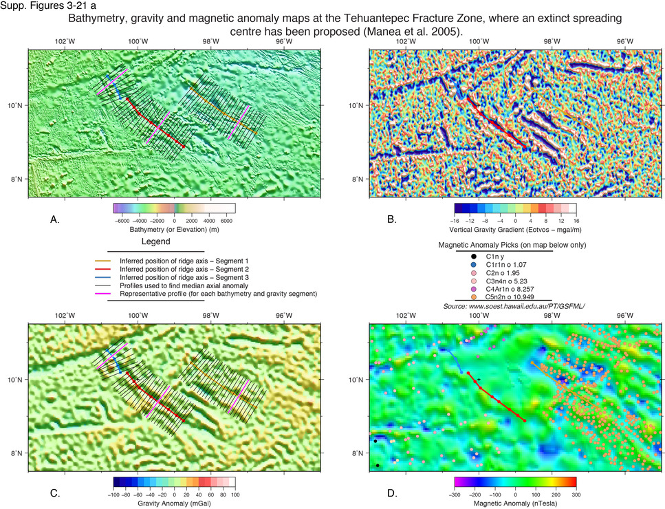
The Tehuantepec ridge is a southwest-trending structure that is oriented at an oblique angle to the dominant tectonic fabric of the surrounding crust in the east Pacific and to the dominant N-S trending magnetic anomalies within the area. The ridge projects around 600 hundred kilometres from the Mexican Coast toward the East Pacific Rise and meets the E-W oriented Siqueiros fracture zone just to the east of this active spreading ridge. It is also at an oblique angle to the Clipperton fracture zone that meets the East Pacific Rise and records the relative motion between the Cocos and Pacific plates (Klitgord and Mammerickx, 1982). Differential ocean floor age (crust to the south is 7-15 Myrs older) across the Tehuantepec fracture zone (FZ) has led some to speculate that an abandoned spreading centre may have been present in this region (Klitgord and Mammerickx, 1982; Manea et al., 2005).
The ridge is situated within the central region of the Cocos Plate, which extends from the Rivera fracture zone in the north to the Cocos-Nazca spreading centre in the south, and meets the Pacific plate on its west at the East Pacific Rise. The Cocos plate is presently being subducted at the Middle America Trench as illustrated in Sclater et al. (1971, their figure 7). On the basis of magnetic lineation trends and depth anomalies Klitgord and Mammerickx (1982) place an abandoned ridge to the south of the Tehuantepec Ridge (see their Figures 1 and 2). However, the regional tectonic map and data compilation of Atwater and Severinghaus (1989) for the North East Pacific indicates that the region of the suspected extinct ridge is uncertain and they do not offer an identification of the measured magnetic anomalies within this region. Klitgord and Mammerickx (1982) observe that the seafloor is deeper with greater distance from their proposed abandoned ridge, yet this depth anomaly is quite subdued and the inferred axial ridge, is very narrow, which does not closely resemble an axial ridge morphology.
A later study (Manea et al., 2005), has incorporated additional magnetic, improved bathymetry and gravity data, and age estimates predicted from a plate-cooling model and a more complex tectonic evolution is proposed. Manea et al. (2005) suggest that two offset spreading centres created a local instability, from a pre-existing long-offset across a fracture zone that is argued to have led to the formation of a briefly active microplate within the Guatemala Basin. The microplate is argued to have formed at around 13 Ma and is bounded to the east by the prominent curved pseudofault that is seen trending east and northeast to the south of the Tehuantepec Ridge (Manea et al., 2005). A linear bathymetric and gravity anomaly with a similar trend to the inferred microplate axis of spreading is also seen to the west of the presumed extent of the microplate in recent global datasets (STRM30, Becker et al., 2009 and Sandwell et al., 2014 gravity). Manea et al. (2005) illustrate their inferred position for the former spreading centre as the 'T1' structure in their Figure 1 inset (p. 65).
Manea et al.'s (2005) model for the ridge evolution suggested that counterclockwise rotation of the EPR axis, which was established at the time of the extinction of the Mathematician spreading ridge, led to instability across the Clipperton FZ that caused a temporary microplate spreading centre that gradually propagated northward until it ceased spreading at 13 Ma, when the spreading centre migrating west to the present day EPR axis. They include an episode of transpression at 20 Ma.
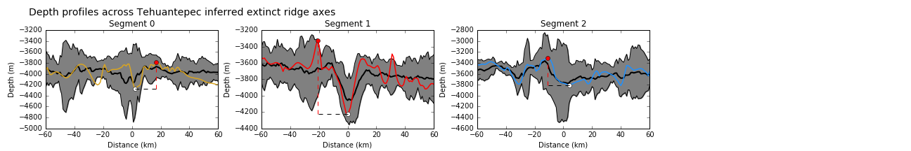
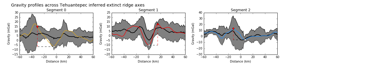
We reviewed the digitized location of the proposed extinct spreading axis and pseudofaults in the region of the Tehuantepec fracture zone (as proposed by Manea et al., 2005). Three of these features were within a standard deviation of the primary tier mean for well-defined extinct ridges although only segment 1 has a symmetric profile that is similar to an extinct ridge axial morphology. Segment 3 has a clearly asymmetric morphology that is particularly evident in the gravity profile and this seggests that it is more likely to represent a fracture zone. There is reasonable evidence to suggest that segment 1 is a former spreading center.
Atwater, T. M. and Severinghaus, J., 1989. Tectonic maps of the northeast Pacific. In, Winterer, E. L., ed, The Geology of North America, The Eastern Pacific Ocean and Hawaii, Vol. N, Geological Society of America, pp. 15–72.
Becker, J.J., Sandwell, D. T., Smith, W. H.F., Braud, J., Binder, B., Depner, J., Fabre, D., Factor, J., Ingalls, S., Kim, S-H., Ladner, R., Marks, K., Nelson, S., Pharaoh, A., Trimmer, R., Von Rosenberg, J., Wallace, G., Weatherall, P., 2009, Global Bathymetry and Elevation Data at 30 Arc Seconds Resolution: SRTM30_PLUS, Marine Geodesy, v. 32, no. 4, p. 355-371.
Klitgord, K.D. and Mammerickx, J., 1982. Northern East Pacific Rise: Magnetic anomaly and bathymetric framework. Journal of Geophysical Research, v. 87, no. 2, p. 6725.
Manea, M., Manea, V.C., Ferrari, L., Kostoglodov, V. and Bandy, W.L., , 2005, Tectonic evolution of the Tehuantepec Ridge, Earth and Planetary Science Letters, v. 238, no. 1-2, p. 64–77.
Sandwell, D., Müller, R. D., Smith, W. H. F., Garcia, E. S., Francis, R., 2014. New global marine gravity model from CryoSat-2 and Jason-1 reveals buried tectonic structure, Science, v. 346, no. 6205, p. 65-67.