| Ocean: | Pacific |
| Spreading centre type: | Large-scale extinct mid-ocean ridge |
| Time of cessation: | Ca. 85 Ma, during the Cretaceous Normal Superchron (Mammerickx and Sharman, 1988) |
| Subsequent active spreading center: | None in immediate area |
| Cessation style: | Not constrained by available data |
| Later deformation or volcanism: | None evident |
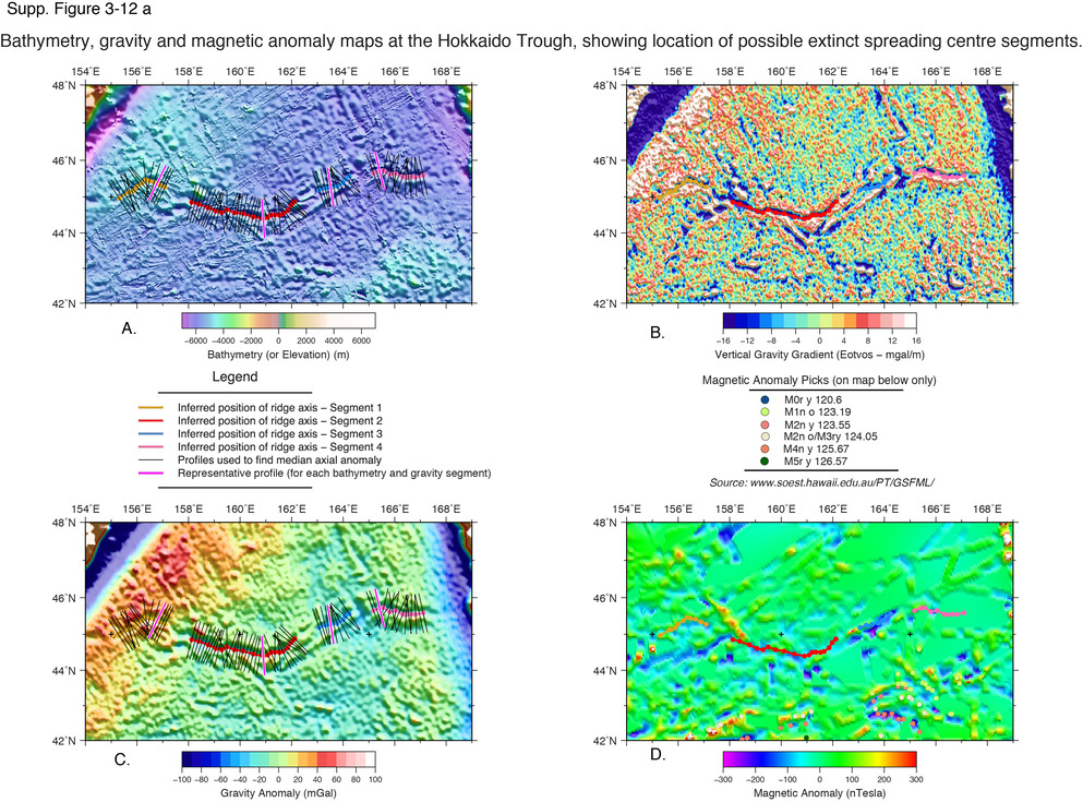
The Hokkaido Trough is an elongate trough oriented roughly east-west, offshore of northern Japan at 45° N. It has been interpreted as a failed spreading centre (Mammerickx and Sharman, 1988). The trough is characterized by a negative free air gravity anomaly of -70 to -100 mGals. The Hokkaido Trough is situated within crust that is inferred to have formed during the Cretaceous Normal Superchron (CNS), which complicates the interpretation of the structure as a former spreading centre due to an absence of magnetic anomaly reversals. It is thought to have formed the plate boundary between the Pacific and either the Kula or the Izanagi Plates, and may have captured crust from the Farallon plate prior to its cessation (Mammerickx and Sharman, 1988; Seton et al., 2012).
In a detailed study of the evolution of the Kula, Pacific and Farallon plate boundaries in the Late Cretaceous, Mammerickx and Sharman (1988) re-evaluated bathymetric and magnetic data to identify the key tectonic features within the northern Pacific Ocean. They observed that the tectonic fabric either side of the trough is oriented NE-SW, parallel to the trough, providing support for the claim that the bathymetric feature may be a former spreading centre (Mammerickx and Sharman, 1988). They propose that the Hokkaido trough created around 100 km of crust and was “propagating westward, but failed within 3 m.y.” (Mammerickx and Sharman, 1988, p. 3021). They suggest that the Izanagi plate was situated to the northwest of the Hokkaido Trough, forming a triple point junction with the Pacific plate at its northern plate boundary and the Kula plate at its western plate boundary (Mammerickx and Sharman, 1988). The Izanagi plate is believed to have been almost entirely subducted at the Aleutian Trench (Seton et al. 2012).
Elsewhere in the Pacific Ocean, it has been argued that spreading may cease when a down-going plate that is entering a subduction zone becomes small enough that the pull force is insufficient to drive magmatic accretion at far-field divergent plate boundaries (Lonsdale, 2005). Yet at the time estimated that the Hokkaido Trough became extinct the ridge would have been significantly further away from the Kuril Trench. There is significant evidence for a major plate reorganization at the time of plate cessation and reorganizations have been a frequent occurrence in the western Pacific during the Mesozoic and Cenozoic eras.
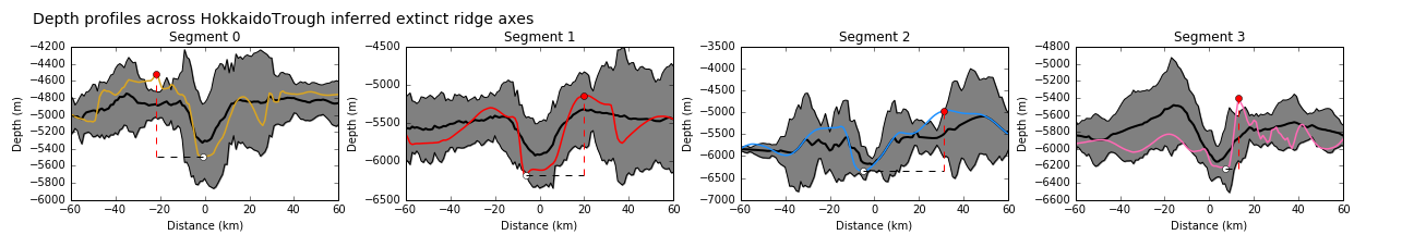
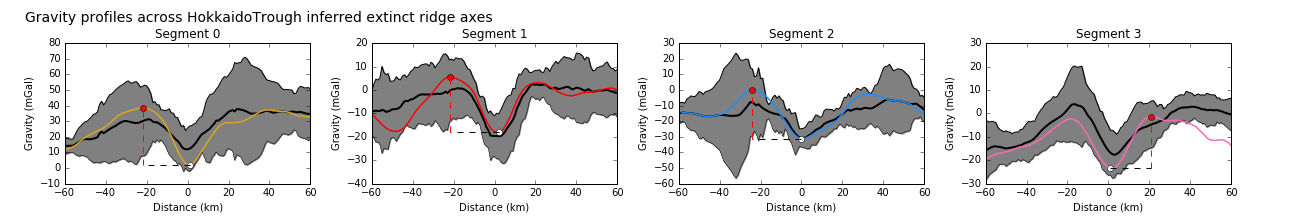
The bathymetric relief and gravity anomalies of the inferred axial segments of the Hokkaido Trough are all within one standard deviation of the mean of well-defined extinct ridges. The trough has similar morphology to a well-defined extinct ridges preserved in the ocean floor. We think that there is good evidence to suggest that the Hokkaido Trough represents an extinct spreading ridge.
Lonsdale, P., 2005, Creation of the Cocos and Nazca plates by fission of the Farallon plate, Tectonophysics, 404, pp. 237-264.
Mammerickx, J. and Sharman, G.F., 1988. Tectonic evolution of the North Pacific during the Cretaceous quiet period. Journal of Geophysical Research, 93, p.3009.
Seton, M. et al., 2012. Global continental and ocean basin reconstructions since 200Ma. Earth-Science Reviews, 113(3-4), pp.212–270.