| Ocean: | Pacific |
| Spreading centre type: | Proposed to be either a leaky transform fault or a mid-ocean ridge that was subject to significant transtension, on a strongly-segmented axis |
| Time of cessation: | Ca. 86 Ma (Chandler et al., 2012) |
| Subsequent active spreading centre: | Pacific-Bellinghausen spreading centre |
| Cessation style: | Not constrained by available data |
| Later deformation or volcanism: | Significant plume related volcanism |
The Ellice Basin is located north of Fiji, between the Ontong Java Plateau to the west and the Manihiki Plateau to the southeast. The oceanic crust in the basin is thought to have formed at the Pacific-Phoenix plate boundary and to have ceased spreading early in the Cretaceous Quiet Zone (Chandler et al., 2012). A later, second reorganization of the Pacific-Phoenix and Farallon plates is argued to have left additional extinct spreading centres in the Penrhyn Basin, at the Tongareva and Osbourn troughs and to the west of the Manihiki Plateau (Taylor et al., 2006; Chandler et al., 2012), with the Osbourn Trough being the only these extinct ridge from this group that has a well-established location and axial structure.
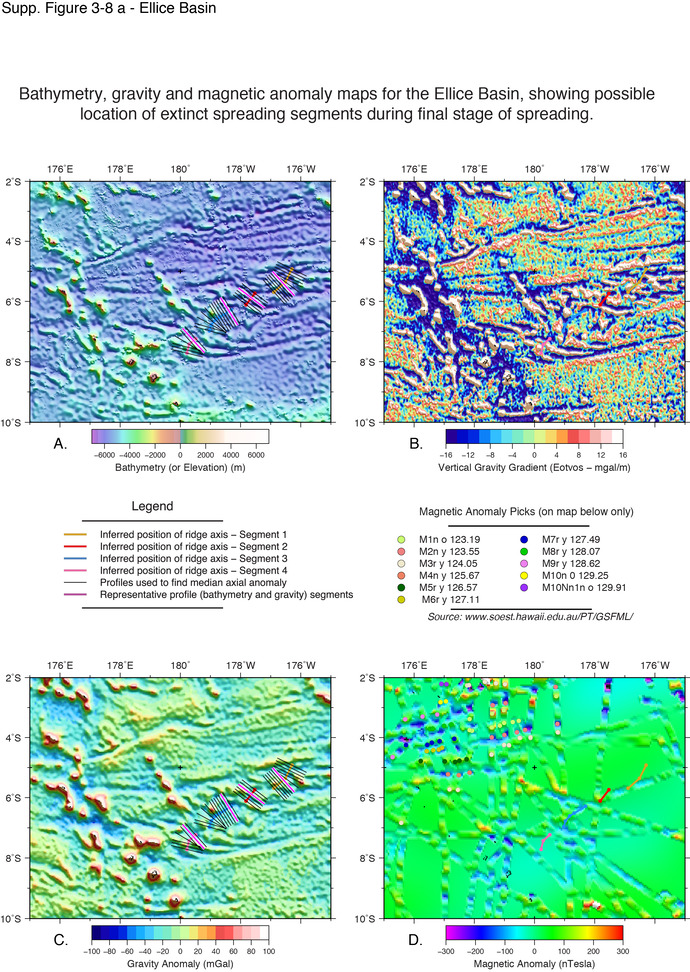
The Ellice Basin has a complex tectonic fabric and is defined by a narrow band of oceanic crust (115-190 km wide by ~1000 km long) oriented roughly east-west that has a sequence of oblique, NW-SE oriented, regularly-spaced, curved fracture zones that transect the band and that meet two sub-parallel linear fracture zones that bound this crustal block to the north and south (evident in maps shown below). Directly north of the complex band and stretching as far as the Nova-Canton Trough (Tamaki et al. 1979), the seafloor is smoother and has more widely spaced and gently curved fracture zones that have a similar orientation to the trend of the set within the narrow zone. South of the band, toward the Robbie Ridge, the seafloor fabric is more chaotic and this could suggest that the south section is not conjugate to the crust north of the narrow band. The region is also complicated by a hotspot trail (the Gilbert seamounts), with seamount chains in this region dated to 58-72 Ma (Taylor, 2006), that obscure the primary tectonic features.
The structural trend and character of the complex band in the Ellice Basin is similar to a segment of the present-day Pacific-Antarctic (PAC-ANT) plate boundary, situated to the south of New Zealand, that connects with the Southeast Indian Ridge (SEIR) to the west. This segment of the PAC-ANT ridge is discussed by Croon et al. (2008) and is thought to be a leaky, sinistral-sense transform fault that accommodates differences in plate motion between the Pacific, Antarctic and Bellinghausen plates, that meet at a triple junction at the eastern end of the SEIR segment. Magnetic anomalies C2An.3n and to C1 have been identified at the Pacific-Antarctic spreading segment and it is currently active, although the crust immediately to the north of the segment formed between chrons C29 and C26 at the former Pacific-Nazca spreading centre (Croon et al., 2008). This necessitates that the recent phase of spreading commenced by rifting of older formed seafloor (see Croon et al., 2008, Figure 5 for detailed maps). The crust on the southern margin of the fault-bounded spreading zone appears to have formed at the Southeast Indian Ridge segment to the west, between chron C24 and the present day. Therefore, the transform-spreading centre postdates both proximal spreading centres by a large margin and appears to only have been active for the last 4 Ma. Active spreading on the leaky transform has produced a strip of crust approximately 160 km wide over 4 Myr (Croon et al., 2008).
The similarity of the width and structural characteristics of the two regions suggests that a similar tectonic environment may have generated the band of crust in the Ellice Basin. Curved fracture zones support a significant transform component at the spreading segment and the centre appears to have been active for a limited time, as evidenced by the bounding fracture zones which truncate the curved fracture zones. Review of the tectonic fabric also suggests that there were two phases of the opening in this basin and that the thin band was the latest phase of spreading. Additionally, magnetic anomalies plotted by Chandler et al. (2012) suggest that magnetic reversals are present, which can be traced across the three parallel profiles that are perpendicular to the spreading direction. These regular reversals suggest that the crust is likely to have formed after the Cretaceous Normal Superchron. Chandler et al. (2012), propose that rotation synchronous with opening of the Ellice Basin led to the complex fabric development in the region.
Not directly discussed by previous studies, however it is likely to have been result of large-scale plate-boundary reorganizations that may have been associated with hotspot proximity.
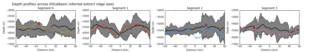
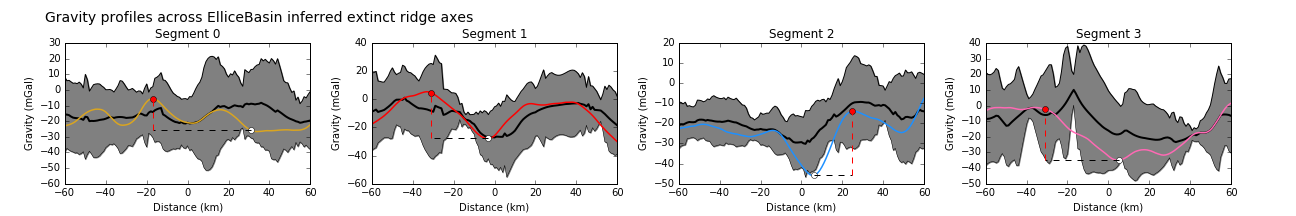
Due to the complexity of the tectonic fabric, it is difficult to isolate the location of the former active spreading ridges within the Ellic Basin because their broad general morphology is dissimilar to many of the other extinct ridges that we review. However, the gravity signal at inferred axial segments were within range one standard deviation of the primary tier (well-defined) extinct ridges and suggest that these are probable extinct spreading centres.
Chandler, M.T. et al., 2012, Reconstructing Ontong Java Nui: Implications for Pacific absolute plate motion, hotspot drift and true polar wander. Earth and Planetary Science Letters, v. 331-332, p. 140–151.
Croon, M.B., Cande, S.C. and Stock, J.M., 2008, Revised Pacific-Antarctic plate motions and geophysics of the Menard Fracture Zone. Geochemistry, Geophysics, Geosystems, v. 9, p .1–20.
Tamaki, K., Joshima, M. and Larson, R.L., 1979, Remanent Early Cretaceous spreading center in the central Pacific basin. Journal of Geophysical Research: Solid Earth, v. 84, no. B9, p. 4501-4510.
Seton et al. 2012. Global continental and ocean basin reconstructions since 200Ma, Earth-Science Reviews, v. 113, no. 3-4, p. 212–270.
Taylor, B., 2006, The single largest oceanic plateau: Ontong Java–Manihiki–Hikurangi, Earth and Planetary Science Letters, v. 241, p. 372–380.